Walking through History: Individual Identity, Directions, and Common Knowledge in Egypt
By Roger Owen
Long ago—sometime in the 1970s—I went looking for the Cairo offices of a charity: al-Jeel. Started and run by a charismatic Egyptian student leader, Ahmed Abdulla, whom I had come to know while he was taking political refuge in Britain a few years earlier, it was located in the Ain al-Sira quarter of the city. This quarter was a dense mixture of the popular housing projects of the Nasser era and more informal dwellings, mostly without numbers and built on streets without names, and addresses tended to assume the character of “Go to such and such a mosque, look for a certain nearby house or a café, and ask for Ali.”
I would like to use this anecdote to say something more general, first about attempts to provide Cairo streets with blue plaques proclaiming names and numbers—a process commonly supposed to go back to at least the late 1840s—then about the associated question of verbal directions given by locals to outsiders wanting to know the way. In so doing I would like to make a small contribution to a literature that, à la Bourdieu, has been largely dominated by questions associated with time and distance rather than direction. To make matters simpler I will only speak of those areas west of Ezbekiya that were progressively built up and filled in during the latter part of the nineteenth century. This happened as the Nile floods were tamed, and lands held in waqf and private estates were progressively broken up as a result of a familiar combination of indebtedness, taxation, and sales conducted by mostly foreign land and mortgage companies, as I described in my Oxford doctoral thesis on the introduction of a cotton-based export economy.[1]
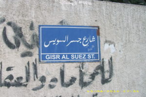
Photo Credit: Ashashyou (Own work) [CC BY-SA 3.0 (http://creativecommons.org/licenses/by-sa/3.0)], via Wikimedia Commons
Let me now give some significant examples of each. Given the continuous but often interrupted desire to provide streets with names and numbers as part of the general process of official control, many of them existed with several names, as in the case of the long avenue that began in the monarchical period with the name “Fuad al-Awal,” only to become “26th of July” after the Nasser-led revolution. Others, in the new suburbs such as Dokki or Maadi or Helwan, quickly lost their official names, perhaps deliberately, it often seemed to me, as a way of avoiding too much official attention. And all made no sense to the illiterate, who could not read street signs anyway, whether in either in Arabic or the ubiquitous French.
As I also know from my work on the 1917 Egyptian national census, there have been occasions when temporary street signs were in place and houses were numbered at a regular height in blue paint to allow all of them to be visited by census takers on the one day assigned to the task, as per the conventional European practice of those days.[2] Yet they too seem to have disappeared over time, leaving the police, the postmen, and others to have recourse to the personal knowledge of local leaders and enforcers such as Shaykh al-Hara and his band of local thugs, the Harafiche. It now seems almost completely beyond official control in some of the newly-built suburban communities.
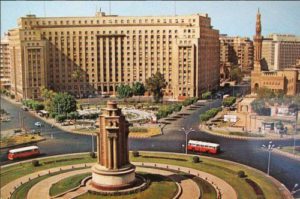
Credit: Nina Awad, “Old Photos of Cairo.” http://stepfeed.com/extra-bits/cookie-jar/old-photos-egypt-will-make-want-go-back-time/?utm_source=facebook&utm_medium=social&utm_campaign=evergreen#.WA8REuUrIdU accessed 25 Oct 2016
Such stubborn concern with personal privacy may also help to account for the lack of success of a series of official attempts to move people in Cairo’s poorer quarters into more salubrious neighborhoods, such as Nasser City, on the city’s desert fringes. Rather, people often prefer life in vast informal settlements such as Manshiyet Nasser—much of it built, according to Heba Saleh, in breach of the law—with an estimated population of 650,000.[3] Hence an almost total absence of building regulations, with little public space and streets so narrow that even fire engines cannot pass through. Hence too a lack of security of title as well as constant problems with falling balconies, sewage and drainage systems, and lack of running water.
Let me now return to my initial concern with outsiders like myself seeking to find their way about. Clearly this poses no problem for those born and bred there, as they were not, say, in the days of Edward William Lane, hanging out all day with his friends just outside the al-Azhar mosque,[4] nor for someone like Ali Mubarak, whose encyclopedic description of mid-nineteenth-century Cairo buildings assumes a knowledge of their street addresses that he does not believe necessary to provide.[5] The outsider, however, perhaps a lone foreigner searching for a mosque or the maidan below the citadel with or without a guide, could probably do with a large repertoire of prominent buildings—not only mosques, churches, and synagogues but also public baths, squares, gates, and some of the larger fountains—that could serve as reference points and be helpful had one of the vernacular phrases at the beginning of a guidebook been put into play to ask someone local the way.
One last observation: in these days one is never alone on a Cairo street, something that, though often oppressive, makes one feel extraordinarily “safe,” night or day. Whether this was also true 150 years ago, when the Baedeker Guides urged foreign travelers to carry lanterns because of the many potholes and other obstructions, I cannot say. But it seems very likely that there has always been someone about to point walkers toward their destination.
Roger Owen
Center for Middle Eastern Studies
Harvard University
August 2015
(Article translated from The Social History Workshop in partnership with Journal of Levantine Studies)
[1] Roger Owen, Cotton and the Egyptian Economy, 1820-1914: A Study in Trade and Development (Oxford: OUP, 1969).
[2] Roger Owen, “The Population Census of 1917 and Its Relationship to Egypt’s Three 19th Century Statistical Regimes,” Journal of Historical Sociology 9, no. 4 (December 1996).
[3] Heba Saleh, “New Foundations,” Financial Times, August 5, 2015.
[4] Edward William Lane, An Account of the Manners and Customs of the Modern Egyptians, 2 vols. (London: C. Knight, 1836).
[5] I am indebted to Professor Eve Powell (University of Pennsylvania) for this observation.

Leave a Reply